
One post tagged with "USU"

View All Tags

Cross-Institutional Collaboration Enhances Hydrologic Modeling in the Logan River Watershed

· 3 min read
Bhavya Duvuri
Machine Learning Researcher
Ayman Nassar
Postdoctoral Researcher
James Halgren
Assistant Director of Science
Arpita Patel
DevOps Manager and Enterprise Architect
Josh Cunningham
DevOps Software Engineer
David Tarboton
Professor at Utah Water Research Laboratory
A before-and-after comparison of the corrected catchment for the Logan River. Text: 'Correcting hydrofabric by removing catchments that do not drain into gauge'
Figure 1. A corrected reach arising from the UA-USU collaboration.

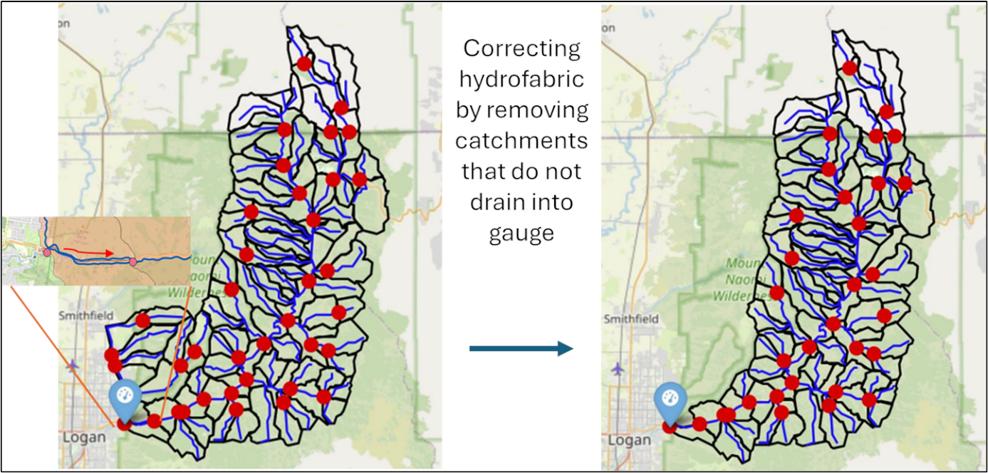
Recent collaboration between researchers in the Cooperative Institute for Research to Operations in Hydrology (CIROH) from University of Alabama (UA) and Utah State University (USU) highlighted the value of cross-institutional partnerships in improving community hydrologic modeling. Focused on the Logan River watershed, this joint effort demonstrated how sharing tools, knowledge, and infrastructure can accelerate both model development and scientific discovery.

Through this engagement, USU researchers gained deeper understanding of the NextGen framework and T-Route modeling library, empowering them to improve physical process representations for the Logan River watershed for heightened simulation fidelity. The collaboration also provided valuable exposure to the developmental side of complex modeling tools, offering insights into framework design, automation workflows, and best practices for model setup and calibration. Both teams benefited from exposure to alternative research tools and methods, which helped enhance and refine the community development pipeline.

One key outcome was the correction of a spatial representation in the Logan River hydrofabric (Figure 1) using the USU’s specific local knowledge. The reach for this region (highlighted in the zoomed subfigure) was updated to reflect its real world path, where it flows into an underwater tunnel that reconnects to Logan River further downstream. This correction will be integrated into the community hydrofabric, benefiting the wider community by improving model realism and reliability. Furthermore, in combination with freshly calibrated model parameters, these updates have improved the model's KGE metric by 0.2 units — a significant gain in model accuracy.

NGIAB played a central role in this success, streamlining the process of setting up, running, and analyzing multiple model configurations. By removing the typical installation and troubleshooting barriers, researchers could focus their time on advancing physical representations rather than infrastructure issues.

This collaboration sets a precedent for how community-driven, open science efforts can improve hydrologic model performance and usability. By combining localized knowledge with shared national tools, we move closer to creating reliable, reusable, and scalable flood forecasting systems, a crucial step for Research-to-Operations (R2O) success.

We look forward to repeating this model of collaboration with other regional experts and academic institutions to continually refine the National Water Model ecosystem and its supporting frameworks.